Shooting for 3D Modeling
The data for the 3D model of our tea house was captured on November 1, 2020. The original motivation is to keep the records of the property as it is, because we can’t afford the full-fledged renovation. However, the realistic data provokes an exciting hunch and inspirations on what we can do by using it.
3D MODELS OF CULTURAL PROPERTIES
3D modeling in the field of cultural treasures has diffused. Some should know Google Arts and Culture. Just to mention an example on how the technology is applied, the service includes “Shuri Castle Digital Reconstruction” project: The old castle in Okinawa prefecture, Japan, supposedly built at the end of the 14th century, was destroyed by a devastating fire in October 2019, then researchers and other stakeholders called on anyone to send photos, videos and memories for a digital reconstruction by building a 3D model of it (for more details, please visit: https://www.our-shurijo.org/en/ ).Besides these cultural heritages sites with high academic and historical value, fortunately, 3D modeling has become more accessible to private building structures.
3D models can be created mainly by laser scanning or photogrammetry. The latter is financially more accessible to ordinary people than laser scanning, as it gives 3D models by taking multiple overlapping pictures and deriving measurements from them. Data for 3D models now can be captured even by smartphones. Thus, it drives the popularization of 3D surveys and modeling. Along with it, the exploitation of constructed models has been diversified and there are growing expectations for further utilization.
THE ARRANGEMENTS
Back to my case, my colleague in a different department went between me and Mr. Nakabayashi from Higashi-Osaka City, Osaka Prefecture. He has successful experience in advancing 3D modeling of the city’s cultural properties and the data publishing. Then he arranged the photogrammetry of our tea house in tandem with a surveying company having strength in historical architectures, SOGO GIKEN. For instance, it has collected dataset of Ninna-ji Temple, a UNESCO World Heritage site in cooperation with Dr. Ari Ide-Ektessabi, a professor emeritus at Kyoto University, then created VR content by using it: https://www.youtube.com/watch?app=desktop&v=GTrRSuT3n_kPAVING THE WAY WITH VOLUNTARY SUPPORTERS
The way for the 3D survey should be paved. Literally, the way to the tea house and the ivy-wreathed house were trimmed by voluntary supporters on Friday, October 30, 2020. As the tea house has been selected as a cultural legacy site of Oyodo town, the expert of the town called over voluntary supporters for weeding. Apart from the survey, wild vegetation is a great enemy to Japanese cultural properties, mostly wooden, so a loose-knit weeding team for the preservation of cultural properties exists in the town. The members of the day are four farmers by profession. I’ve met one of the members this July. At that time, he came over to our tea house as a member of the Oyodo study group for paleography.The specialists in vegetation made neat the mountain on which the tea house stands, with their own mowing machines and pruners for about two hours. I wish I would have taken pictures before their contribution for comparison.
My uncle had cut grass about two weeks earlier, but the vegetation here was rapidly grew in a still warm environment, and we just found droppings of a wild boar on the way to the tea house, that means it had been almost an animal trail. But now the house including the way to it looks neatest in the last dozen of years or so. Thick branches which blocked the view were also eliminated.
 |
| After mowing |
THE 3D SURVEY
The 3D survey was conducted on Sunday, November 1, 2020. At 10am showed up Mr. Uchiyama, CEO, and Mr. Watanabe, Head of the Kyoto Office, both from Sogo-giken, as well as Mr. Nakabayashi. Higashi-Osaka City is located in Osaka Prefecture, adjacent to the western part of Nara Prefecture, which includes our Oyodo Town.Before their arrival, we carry the furniture and interior goods out from the tea room. But we didn’t slide open the wooden shutters, as the glass windows behind the shutters may skew the data by the reflection.
We went with photogrammetry. Very roughly speaking, we took countless photos from different angles to capture each part by overlapping enough from one to the next. Then pictures are integrated and corrected by the information on the position and inclination in three-dimensional space, which were separately measured.
MEASUREMENTS BY A TOTAL STATION
The survey started with the observation by a total station, an optical instrument, commonly used in construction and surveying by measuring horizontal angles, vertical angles and distance to any target point like a peg or a corner of members in the format of Ground Contol Point. Such figures are to complement 3D data for more accurate three-dimensional location/scale.
Ground Contol Points were captured from some points by moving the total station for several times. The object of the survey was a building construction on the slope of the small mountain, and the pathway to it is narrower than one meter and folded every 6 to 8 meters like an accordion. Moreover, some thick branches remain. In a word, appalling conditions for measurements.

 |
| Total station |
TAKING PICTURES, PICTURES, AND PICTURES
Countless photos were taken by an instrument, a seven-meter pole with multiple lens-style cameras, for the external appearance; and a digital camera we usually see for inside. Even a handheld object needs at least 100 pictures to create a quality 3D model, and a whole building far many more.
Mr. Uchiyama and Mr. Watanabe recorded the tea house by sliding the pole vertically little by little so that pictures overlap 60 to 80% each other. Despite the multi-camera setup, it took considerable time. I felt sorry for the bad geographical conditions...
 |
| Photo shooting with multiple cameras |
VIDEO SHOOTING BY A DRONE
It had been easier to imagine what a drone would do than other devices, but actually I got a close look at a drone for the first time. It was bigger than thought.
The dust rolled at the moment of takeoff. Then the drone moved up and down, flew level, and hovered while recording. I saw the mastery of drone operation.
Drone observation in Japan sometimes causes a complaint from neighborhood residents on its noise or privacy issues. But no problem for this case, as we were in the privately owned mountain.
 |
| Drone |
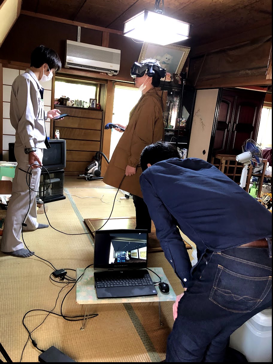
In between observations, we experienced a VR program for a virtual museum which was displayed by Higashi-Osaka City at ICOM Kyoto 2019 (ICOM - International Council of Museums). Mr. Nakabayashi was in charge of the project. In the virtual reality, I could hold a clay vessel excavated in the city, stand in the middle of remains of a temple-gate (switching from remains to restoration with the push of a button), and look at anywhere in a two-dimensional illustrated handscroll with a magnifying glass.
In fact, the expert from the local authority, ex- and incumbent heads of the ward (the town subordinates some wards) and others came over, or just passed by, one after another during the survey. They also enjoyed the VR content and looked positive about the cutting-edge technology.
The survey started at 10am and ended a little passed 4pm. So, it took three experts almost whole day to collect the records. The data achieved is indeed innovative, but that’s why it’s not an instant product.
In fact, the expert from the local authority, ex- and incumbent heads of the ward (the town subordinates some wards) and others came over, or just passed by, one after another during the survey. They also enjoyed the VR content and looked positive about the cutting-edge technology.
 |
| VR experience |
The survey started at 10am and ended a little passed 4pm. So, it took three experts almost whole day to collect the records. The data achieved is indeed innovative, but that’s why it’s not an instant product.
That being said, there are a lot of old Japanese houses with mediocre academic and historical values: Even though the owners and other stakeholders don’t wish to abandon, the public sector can’t afford to protect them. In terms of pricing sensitivity, rarely few people can splash out big cash on decent renovation (usually far exceeds 100,000USD), but a wider stratum may see value worth 3D modeling (thousands of dollars, depending on properties).
For me, 3D modeling is like hibernation or frozen storage of cultural properties: to keep accurate records for the time being, so that the properties may die or sleep in the hope that future technological innovation could enable high-quality and affordable restoration, or any other usage beyond the imagination of us for today.


Comments
Post a Comment